Department News & Events
Department News
New Bachelor of Arts Sustainability Science Degree
Beginning in Fall 2025, undergraduate students will have the opportunity to complete a BA degree in Sustainability Science. This new degree program will provide students with a solid foundation in the natural sciences, exposure to an interdisciplinary perspective from the social sciences and the humanities, and instruction in research skills necessary to compete in the ever growing field of sustainability Learn more about the BA Sustainability Science degree.
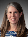
Dr. Helen Hazen Named University of Denver Outstanding Teacher
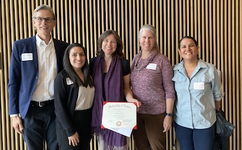
Dr. Helen Hazen (center) was selected as the 2024-2025 recipient of the University’s Distinguished Teaching Award! This is a prestigious honor and the highest recognition of teaching excellence at the University of Denver. Dr. Hazen is extremely intelligent and knowledgeable, a conscientious team-player, a true champion of our discipline and student learning, deeply invested in her teaching and continual improvement of teaching, and has become a model teacher for others to learn from. The official celebration and recognition ceremony held in January 2026.
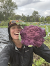
Students Travel to Antarctica
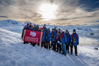
In December 2025, Dr. Erika Trigoso led an interterm course to Antarctica. Our department has now offered field courses to all continents!
Focus on Alumni
Katie Ketchum (BA Geography 2018) is making a difference in sustainable agriculture. Read about her journey here.
Faculty Updates
Research Grants

Dr. Michael Kerwin is co-PI on a recently awarded NSF grant titled "IRES: Nature-based Solutions research to support water security in peri-urban areas”. Furthermore, this project includes former PhD student Dr. Joe Hoover (co-PI) and former PhD student and former visiting professor Dr. Thomas Lavanchy (PI).

Dr. Hanson Nyantakyi-Frimpong is a co-applicant with a large team of scholars who secured grant funding in the amount of CAN$2,499,630 from the Government of Canada to work on climate change, agroecology and equity issues in Africa. The project is titled Participatory Agroecological Research for Transforming Knowledge and Equity in African Communities (PARTAKE Africa). The grant duration is 7 years and will support numerous students in our department.
In the News

Dr. Andrew Goetz was interviewed by 9News, Denver7, and Fox 31 regarding the neighborhood impacts for the preferred new Broncos stadium site at Burnham Yards.
Dr. Michael Kerwin was interviewed about Colorado geology, Colorado River water resources issues, and the reasons for Denver's record warmth and lack of snowfall.
- An Expert's Guide to Colorado's Coolest Rock Formations
- The Colorado River: What we can do to help water conservation efforts?
- The Colorado River: Lifeblood for the American West
- Denver's Record Warmth and Lack of Snowfall
Dr. Hillary Hamann was interviewed about Denver Water's approach to climate change challenges.
Recent Faculty Publications
Boschmann, E. (2024). Daily trip making during the COVID-19 pandemic: A national survey of older adults in the United States. Travel Behaviour and Society, 34, 100683.
Dobruszkes, F., Chen, C.-L., Cidell, J., Condeco-Melhorado, A., Goetz, A. R., Ryley, T., & Thevenin, T. (2023). New and emerging pathways for transport geography. In Jerzy Banski & Michael Meadows (Eds.), Research directions, challenges, and achievements of modern geography. (pp. 39-59). Cham: Springer. 9789819966042.
Goetz, A. R. (2023). The Interstate Highway 70 reconstruction project in Denver: Repeating a 1960s planning failure? In Robin Hickman & Christine Hannigan (Eds.), Discourse analysis in transport and urban development: Interpretation, diversity, and controversy. London: Edward Elgar. 9781802207194.
Goetz, A. R., Perl, A. D., Bruun, E. C., & Zimny-Schmitt, D. (2023). Exploring the potential of providing high-speed intercity passenger rail service to Chicago’s O’Hare International Airport. Chicago, IL: High Speed Rail Alliance.
Hazen, H. D., Alberts, H. C., & Zaniewski, K. J. (2023). Population geography: Social justice for a sustainable world. New York: Routledge. 9780367697075.
McCarroll, M., LaVanchy, G. T., & Kerwin, M. W. Tourism resiliance to drourhg and climate shocks: The role of water literacy in hotel management. Annals of Tourism Research Empirical Insights, 5(4), 1-10.
He, Z., Zhang, T., Wang, W., & Li, J. (2024). A Deep Pedestrian Trajectory Generator for Complex Indoor Environments. To appear in Transactions in GIS.
Entwistle, J.R. & Nyantakyi-Frimpong, H. (2025). Community land governance in Liberia: Implications for tenure security and land concessions. Land Use Policy, 153, 107555.
Stock, R. & Nyantakyi-Frimpong, H. (2025). Laboring for light: energy unfreedoms and freedom dreams of solar labor in Ghana. The Journal of Peasant Studies, 52 (2), 235-257
Nyantakyi-Frimpong, H., & Carlson, A. (2024). Seed sovereignty, knowledge politics, and climate change in northern Ghana. In Rachel Wynberg (Ed.), African perspectives on agroecology: Why farmer-led seed and knowledge systems matter. (pp. 115-132). Rugby, UK: Practical Action Publishing. 9781788530224.
Boafo, J., Yeboah, T., Guodaar, L., Yamoah, S. & Nyantakyi-Frimpong, H. (2024). Understanding non-economic loss and damage due to climate change in Ghana. Climate and Development, 16 (2), 109-118.
Dinko, D. H., Kansanga, M., Nyantakyi-Frimpong, H., & Luginaah, I. (2024). Unpacking the dynamics of natural resource conflicts: The case of African rosewood. Land Use Policy, 136, 106962: 1873-5754.
Kpienbaareh, D., Kerr, R. B., Nyantakyi-Frimpong, H., Iverson, A., Luginaah, I., Lupafya, E., ... & Shumba, L. (2024). Ecosystem service demand and supply dynamics under different farming systems: A participatory GIS assessment in Malawi. Applied Geography, 171, 103372.
Rasmussen, L.V., Grass, I., Mehrabi, Z., Smith, O.M., Bezner-Kerr, R., Blesh, J., Garibaldi, L.A., Isaac, M.E., Kennedy, C.M., Wittman, H., Batáry, P., Buchori, D., Cerda, R., Chará, J., Crowder, D.W., Darras, K., DeMaster, K., Garcia, K., Gómez, M., Gonthier, D., Hidayat, P., Hipólito, J., Hirons, M., Hoey, L., James, D. John, I., Jones, A.D., Karp, D.S., Kebede, Y., Bezner Kerr, C., Klassen, S., Kotowska, M., Kreft, H., Llanque, R., Levers, C., Lizcano, D.J., Lu, A., Madsen, S., Marques, R.N., Martins, P.B., Melo, A., Nyantakyi-Frimpong, H., Olimpi, E.M., Owen, J.P., Pantevez, H., Qaim, M., Redlich, S., Scherber, C., Sciligo, A.R., Snapp, S., Snyder, W.E., Steffan-Dewenter, I., Stratton, A.E.,Taylor, J.M.,Tscharntke, T., Valencia, V., Vogel, C. and Kremen, C. (2024). Joint Environmental and Social Benefits from Diversified Agriculture. Science, 384 (6691), 87-93.
Najjar, D., Nyantakyi-Frimpong, H., Devkota, R., & Bentaibi, A. (2023). A feminist political ecology of agricultural innovations in smallholder farming systems: Experiences from wheat production in Morocco and Uzbekistan. Geoforum, 146, 103865.
Dinko, D. H., & Nyantakyi-Frimpong, H. (2023). Uneven geographies of the embodied effects of water insecurity among women irrigators in northern Ghana. Annals of the American Association of Geographers, 113(10), 2417-2434.
Stock, R., Nyantakyi-Frimpong, H., Antwi-Agyei, P., & Yeleliere, E. (2023). Volta photovoltaics: Ruptures in resource access as gendered injustices in Ghana. Energy Research & Social Science, 103, 103222: 2214-6326.
Nyantakyi-Frimpong, H., Dinko, D. H., & Bezner Kerr, R. (2023). Floodplain farming and maladaptation to extreme rainfall events in northern Ghana. Climate and Development, 15(3), 201-214. 1756-5537.
Nyantakyi-Frimpong, H., Christian, A. K., Ganle, J., & Aryeetey, R. (2023). “Now we’ve all turned to eating processed foods”: A photovoice study of the food and nutrition security implications of ‘galamsey’ in Ghana. African Journal of Food, Agriculture, Nutrition and Development, 23(1).
Elvidge, C. D., Zhizhin, M., Sparks, T., Ghosh, T., Pon, S., Bazilian, M., Sutton, P. C., & Miller, S. D. (2023). Global Satellite Monitoring of Exothermic Industrial Activity via Infrared Emissions. Remote Sensing, 15(19), 4760.
Rothman, D. S., Raskin, P., Kok, K., Robinson, J., Jäger, J., Hughes, B., & Sutton, P. C. (2023). Global Discontinuity: Time for a Paradigm Shift in Global Scenario Analysis. Sustainability, 15(17), 12950: 2071-1050.
Moran-Taylor, M. J., Taylor, M. J., & Galemba, R. Migration and Climate in Western Guatemala. Focus on Geography.
Zhang, G. (2024). A web-based geovisualization framework for exploratory analysis of individual VGI contributor’s participation characteristics. Cartography and Geographic Information Science. 1545-0465.
Huang, X., Wang, S., Yang, D., Hu, T., Chen, M., Zhang, M., Zhang, G., Biljecki, F., Lu, T., Zou, L., Wu, C. Y. H., Park, Y. M., Li, X., Liu, Y., Fan, H., Mitchell, J., Li, Z., & Hohl, A. (2024). Crowdsourcing geospatial data for earth and human observations: A review. Journal of Remote Sensing, 4, 0105.
Zhang, G., Gong, X., & Zhu, D. (2024). Geographic proximity and homophily effects drive social interactions within VGI communities: An example of iNaturalist. International Journal of Digital Earth, 17(1), 2297948.
Zhang, G., Luo, W., Wu, M., & Ye, L. (2025). Exploring social interaction patterns and drivers in VGI communities using a custom geovisual analytics tool. Annals of GIS, 31(3): 413-431
Graduate Student Updates
Graduate Student Awards
Julia Entwistle (doctoral student) - College of Natural Sciences and Mathematics Outstanding Graduate Research Award
Alex Van De Water (MSGIS student) - College of Natural Sciences and Mathematics Outstanding Graduate Service Award
Jin Xu (doctoral student) -
- Third place, Best Student Paper Competition, The 32nd International Conference on Geoinformatics (Henan, China).
- Third place, Student Poster Award, UCGIS Symposium 2025 (Laramie, WY).
Graduate Student Publications
Baysal, U. (2024). Desperately Seeking Sustainable Human Well-Being: A Review of Indicators, Concepts, and Methods. SCIPublish. 1(3). DOI: 10.35534/ecolciviliz.2024.10004
Chatterjee, N., Tilottama G, Christopher D E, Mikhail Z, Tamara S. (2023).Uncovering the Effects of the Southwest Monsoon on Fishing Activity in the Indian Ocean with VIIRS Boat Detection Data. Oceanography Fish Open Access Journal 16(5): 555948. DOI: 10.19080/ OFOAJ.2023.16.555948
Elvidge CD, Ghosh T, Chatterjee N., Zhizhin M, Bazilian M. (2023). Discovering Hidden Offshore Lighting Structures with Multiyear Low-Light Imaging Satellite Data. Oceanography Fish Open Access Journal 16(4): 555944. DOI: 10.19080/OFOAJ.2023.16.555944
Elvidge, C. D., Ghosh, T., Chatterjee, N., & Zhizhin, M. (2023). Lights on the Water? Accumulating VIIRS boat detection grids in Southeast Asia spanning 2012–2021. Fish for the People, 21(1), 33-38.
Tenenbaum, J. (2023). Competing National Identities in the Landscape of Rapa Nui. Focus on Geography 66. DOI: 10.21690/foge/2023.66.2f
Undergraduate Student Updates
Undergraduate Student Receives Honda Inspiration Award.
Sidney Barbier (BS Environmental Science 2025) was named the recipient of the Class of 2025 Honda Inspiration Award. Celebrating its 37th year, the Honda Inspiration Award recognizes a female collegiate athlete in NCAA Division I, II, or III who has triumphed in the face of extraordinary physical and/or emotional adversity, injury, illness, or personal sacrifice during her collegiate experience, and who has returned to achieve athletic success.
DU Undergraduate Research and Scholarship Showcase
The DU Undergraduate Research and Scholarship Showcase celebrates research achievements of undergraduate students across the University. At the event students present posters and presentations of their undergraduate research. We are delighted that the following Geography, Environmental Science or GIS majors showcased their research projects at this event:
Sidney Barbier How to Solve a Wicked Problem: An Introduction to Environment, Society and Sustainability
William Christensen & Olivia Kachulis Effects of Biochar on Short-Term Growth in Pinus contorta var. latifolia
Paola Gascot-Chinea Collection and Analysis of Chemical Reaction Products When Protein Samples Are Exposed to Denver Urban Air
Elsie Harrington Preserving Paradise: Investigating Beach Littering Behaviors and Developing Sustainable Solutions in Coastal Nicaragua
Joslyn Hays Causes Of Hatching Failure In Great Tit (Parus major) And Blue Tit (Cyanistes caeruleus) Populations In Comparison Of Urban-Rural Areas
Allie Leary Lab Experiments to Optimize a Newly Developed Ultrafine Particle Counter
Emmy Radin Participative Citizenship in Mashpi, Ecuador: Meaningful and Sustainable Models for Education and Conservation
Christine Stadnik-Poteroba Multivocality Of The California Gold Rush: The Inter-oceanic Route Via Nicaragua
Mia Supan The Accumulation of Anthropogenic Debris on Beaches in Nicaragua
Alyssa Knaus Atmospheric Particulate Matter (PM) Trends Of The Front Range Of Colorado Via PurpleAir Sensors
-
Class of 2025 Graduates
Congratulations to the Class of 2025!
PhD (Geography):
Uma Baysal, Toward a Sustainable Well-Being: A Multidimensional Assessment for Colorado, (Sutton)
Jecca Bowen, Political Ecologies of the Livestock Industry, (Nyantakyi-Frimpong)
Namrata Chatterjee, Lights at Night: Indicators of Urbanization, Socio-economic Change, and Sustainability Progress, (Sutton)
MS (Geographic Information Science):
Jack Borski, Utilizing Spatial Criteria to High-grade Wyoming EOR Opportunities Along Proposed Pipeline Corridors: A Value Driven Approach, (Hick)
Robert Brown, A Comparative GIS Analysis of United and Southwest Airlines Route Networks, (Hick)
Marc Di Placido, GIS-Based Water Reservoir Locations, (Kuzera)
Devin Escue, Visualization of Indiana and Northern Long-Eared Bats Using Spline Surfaces To Enable Targeted Land Management, (Hick)
Hanna Gilhooley, How Short-Term Rentals Impact Summit County, Colorado, Spa;ally and Economically: A GIS Analysis, (Hick)
Erik Gilmore, A GIS Approach to Predictive Wildfire Mapping in the Pike National Forest, (Hick)
Joslyn Hays, Wet Meadow Restoration Prioritization Modeling Project,(Hamman)
Tara Hoelzer, Object-Based Image Analysis and Artificial Intelligence Identification of Anthropogenic Disturbance on Lesser Prairie Chicken Habitat in Cheyenne County, Colorado, (Hick)
Amelia Horton, Spatial Analysis of PM2.5 Pollution Using Crowdsourced Data in Chicago, Illinois, (Hick)
Jake Hostnik, Wolverine Habitat Suitability Analysis in Lake County, Colorado, Using GIS, (Hick)
Daniel Kinkaid, Using Historic Glacial Data and GIS to Predict Mount Rainier National Park’s Glacial Future, (Hick)
Bianca Kumar, Developing a Public Integrated Web GIS Hub Portal for Summit County, Colorado, (Hick)
David Lackajs, Key Largo Mangrove Population Monitoring: A Remote Sensing Analysis and Classification Methodology Review, (Hick)
Brandon McAllister, A Spatial Analysis of Residential Photovoltaic Adoption in New Jersey: Focusing on 2020 With Trends Through 2025, (Hick)
Austin Rushinsky, Comparison and Critique of Radon Data in Jefferson County, Colorado, (Kuzera)
Georgia Schneider, Navigating the Challenges of Creating a Secure, Spatial Cave and Karst Resources Inventory and Tracking Geodatabase for the Geologic Resources Division of the National Park Service, (Hick)
Alex Van De Water, Salmon Fishery Management, (Nyantakyi-Frimpong)
BA (Environmental Science): Benjamin Albro, Nadeen Ameer, Kathryn Baker, Kaela Belknap, Chloe Benson, Charles Contag, Emilia Cooper, Nathan Cox, Giovanna Davison, Giovanna Drake, Grant Endresen, Rose Keaton, Ella Marsden, Colleen Meighan, Morgan Oglesby, Sidney Parker, Casie Parrish, Maggie Ryan, Nina Sachs, Samantha Sameshima, Logan Simson, Nicollette Tanino-Springsteen, Lillian Wertz, Rebekah Wright.
BA (Geography): Ines Allen, Charlotte Bond, Abigail Brewer, Jack Callahan, Aden Callahan, Griffin Cascarino, Gerardo Cruz, Carmen Cunningham, Maclean Donovan, Michael Fitzsimmons, Daniella Holstein, Maxwell Jadlos, Carson Jones, Jacqueline Lanning, Mark Mazzatta, Peter Michel, Audrey Singer, Kenna Stephen.
BS (Environmental Science): Albertine Arnfield, Sidney Barbier, Rose Bracken, William Christensen, Makenna DiDonato, Emily Fisher, Rachel Jaeger, Eleanor Jones, Olivia Kachulis, Alicen King, Kaimbry Kugeler, Joseph Lumer, Catherine Malatesta, Anna Marlow, Ella Mathews, Meghan O'Reilly, Sarah Olson, Sammy Ortiz, Uriel Perez, Timothy Place, Isla Saylor, Norah Schroder, Rebecca Short.
BS (Geographic Information Science): Claire Batson, Sarah Brinkmann, Theodore Canji, Freya Crook, Johanna Hunt, Skylar Mc Williams, Jason Tipler.
-
2025 Department Awards
Congratulations to this year's award recipients!
Dr. Laurence C. Herold Memorial Award for Outstanding Graduate Teaching Assistants: Joslyn Hays, Alexandra van de Water
Dr. Robert D. Rudd Memorial Award for Outstanding Graduate Student Research: Namrata Chatterjee
Dr. David B. Longbrake Award for Outstanding Undergraduate Service in Geography: Logan Simson
Professor Moras L. Shubert Award for Outstanding Undergraduate Scholarship in Environmental Science: Sidney Barbier
Environmental Science Award for Outstanding Undergraduate Research in Environmental Science: Kiena Campbell, Norah Shroder
Paul Stanford Bernhard Memorial Scholarship in Environmental Science: Tatiana Peccedi
Alan Bryce Henry Memorial Scholarship in Environmental Science: Haven White
Dr. Thomas M. Griffiths Memorial Award for Undergraduate Scholarship and Research: Carmen Cunningham, Audrey Singer
-
2025 Herold Fund Research Awards
Created in 2010, this fund honors the memory of Professor Laurance C. Herold, a faculty member in the Geography Department from 1963 through 1996, who led many student field research expeditions, notably to study prehistoric agricultural terraces in the Sierra Madre Occidental of Chihuahua and Sonora, Mexico. The Laurance C. Herold Fund supports field research by graduate and undergraduate students as part of their degree programs in the Department of Geography & the Environment.
Additional support provided by the Longbrake Family Foundation.
Congratulations to this year's Herold Fund awardees:
Julia Entwistle: A qualitative approach to understanding large-scale plantation agriculture and dietary diversity in Liberia.
Andrews Ofosu: A decolonial approach to exploring climate change maladaptation in Ghana.
Queen Olafadahan: Impacts of ecotourism on deforestation and revenue distribution: A qualitative exploration of local community perspectives at Lekki Conservation Center, Nigeria.
Stephanie Yamoah: Evaluating the efficacy and community engagement of agroforestry-based climate solutions in Ghana.